Urban Planning & Design Designing Local 5/4/26 Urban Planning & Design Designing Local 5/4/26 Orem Heart Downtown Master Plan Orem, Utah Read More Public Art Planning, Community Engagement, Arts & Culture Planning, Urban Planning & Design, Landscape Architecture Designing Local 4/21/26 Public Art Planning, Community Engagement, Arts & Culture Planning, Urban Planning & Design, Landscape Architecture Designing Local 4/21/26 Reimagining Columbus Columbus, Ohio Read More Landscape Architecture, Urban Planning & Design, Community Engagement, Parks & Recreation Matt Leasure 2/17/25 Landscape Architecture, Urban Planning & Design, Community Engagement, Parks & Recreation Matt Leasure 2/17/25 Brunswick Parks & Recreation Master Plan Read More Landscape Architecture, Urban Planning & Design Matt Leasure 1/6/25 Landscape Architecture, Urban Planning & Design Matt Leasure 1/6/25 Racine Riverfront Revitalization Read More Landscape Architecture, Urban Planning & Design, Community Engagement, Parks & Recreation Matt Leasure 1/1/25 Landscape Architecture, Urban Planning & Design, Community Engagement, Parks & Recreation Matt Leasure 1/1/25 Marsh Park Master Plan Read More Urban Planning & Design Designing Local 9/23/24 Urban Planning & Design Designing Local 9/23/24 Fairfield Town Center Placemaking Strategy Read More Landscape Architecture, Urban Planning & Design, Parks & Recreation Matt Leasure 8/16/24 Landscape Architecture, Urban Planning & Design, Parks & Recreation Matt Leasure 8/16/24 Rickenbacker Woods Park Read More Urban Planning & Design, Parks & Recreation Designing Local 4/5/24 Urban Planning & Design, Parks & Recreation Designing Local 4/5/24 Central Ohio Greenways Wayfinding Strategy Guide Read More Landscape Architecture, Urban Planning & Design, Community Engagement, Parks & Recreation Matt Leasure 10/17/23 Landscape Architecture, Urban Planning & Design, Community Engagement, Parks & Recreation Matt Leasure 10/17/23 Fort Wayne 5-Year Parks & Recreation Master Plan Read More Landscape Architecture, Urban Planning & Design, Parks & Recreation Matt Leasure 10/17/23 Landscape Architecture, Urban Planning & Design, Parks & Recreation Matt Leasure 10/17/23 New Haven- Adams Township 2023-2027 Parks & Recreation Master Plan Read More Urban Planning & Design, Landscape Architecture, Parks & Recreation Matt Leasure 10/17/23 Urban Planning & Design, Landscape Architecture, Parks & Recreation Matt Leasure 10/17/23 Allen County Parks 2023-2027 Parks & Recreation Master Plan Read More Historic Preservation, Landscape Architecture, Urban Planning & Design Matt Leasure 6/15/22 Historic Preservation, Landscape Architecture, Urban Planning & Design Matt Leasure 6/15/22 Ohio & Erie Canal Southern Descent Heritage Trail Read More Landscape Architecture, Urban Planning & Design, Parks & Recreation Matt Leasure 6/15/22 Landscape Architecture, Urban Planning & Design, Parks & Recreation Matt Leasure 6/15/22 Lockbourne Veterans Park Read More Landscape Architecture, Urban Planning & Design Matt Leasure 6/15/22 Landscape Architecture, Urban Planning & Design Matt Leasure 6/15/22 Columbus Urban Forestry Master Plan Read More Landscape Architecture, Parks & Recreation Matt Leasure 10/1/21 Landscape Architecture, Parks & Recreation Matt Leasure 10/1/21 Tuttle Park Lower Field Improvements Read More Landscape Architecture, Urban Planning & Design, Parks & Recreation Designing Local 9/13/19 Landscape Architecture, Urban Planning & Design, Parks & Recreation Designing Local 9/13/19 Cape May County Creative Placemaking Plan Read More Landscape Architecture Matt Leasure 5/28/19 Landscape Architecture Matt Leasure 5/28/19 Dublin Arts Center Event Terrace & Cabin Reconstruction Read More
Urban Planning & Design Designing Local 5/4/26 Urban Planning & Design Designing Local 5/4/26 Orem Heart Downtown Master Plan Orem, Utah Read More
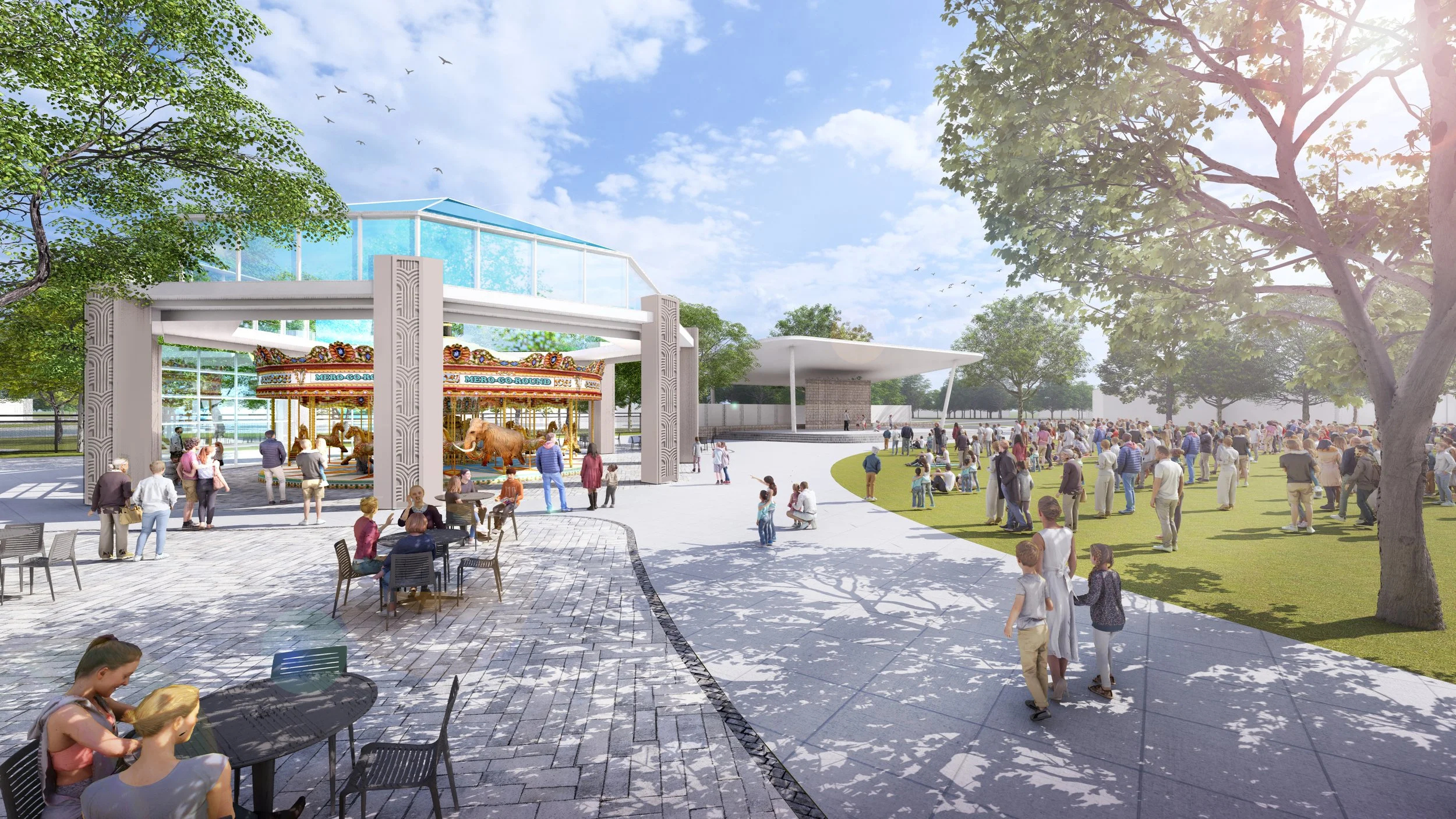
Public Art Planning, Community Engagement, Arts & Culture Planning, Urban Planning & Design, Landscape Architecture Designing Local 4/21/26 Public Art Planning, Community Engagement, Arts & Culture Planning, Urban Planning & Design, Landscape Architecture Designing Local 4/21/26 Reimagining Columbus Columbus, Ohio Read More
Landscape Architecture, Urban Planning & Design, Community Engagement, Parks & Recreation Matt Leasure 2/17/25 Landscape Architecture, Urban Planning & Design, Community Engagement, Parks & Recreation Matt Leasure 2/17/25 Brunswick Parks & Recreation Master Plan Read More
Landscape Architecture, Urban Planning & Design Matt Leasure 1/6/25 Landscape Architecture, Urban Planning & Design Matt Leasure 1/6/25 Racine Riverfront Revitalization Read More
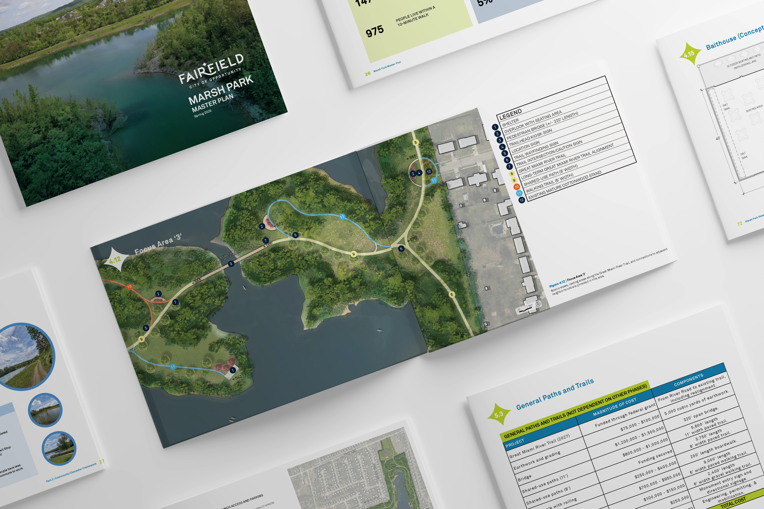
Landscape Architecture, Urban Planning & Design, Community Engagement, Parks & Recreation Matt Leasure 1/1/25 Landscape Architecture, Urban Planning & Design, Community Engagement, Parks & Recreation Matt Leasure 1/1/25 Marsh Park Master Plan Read More
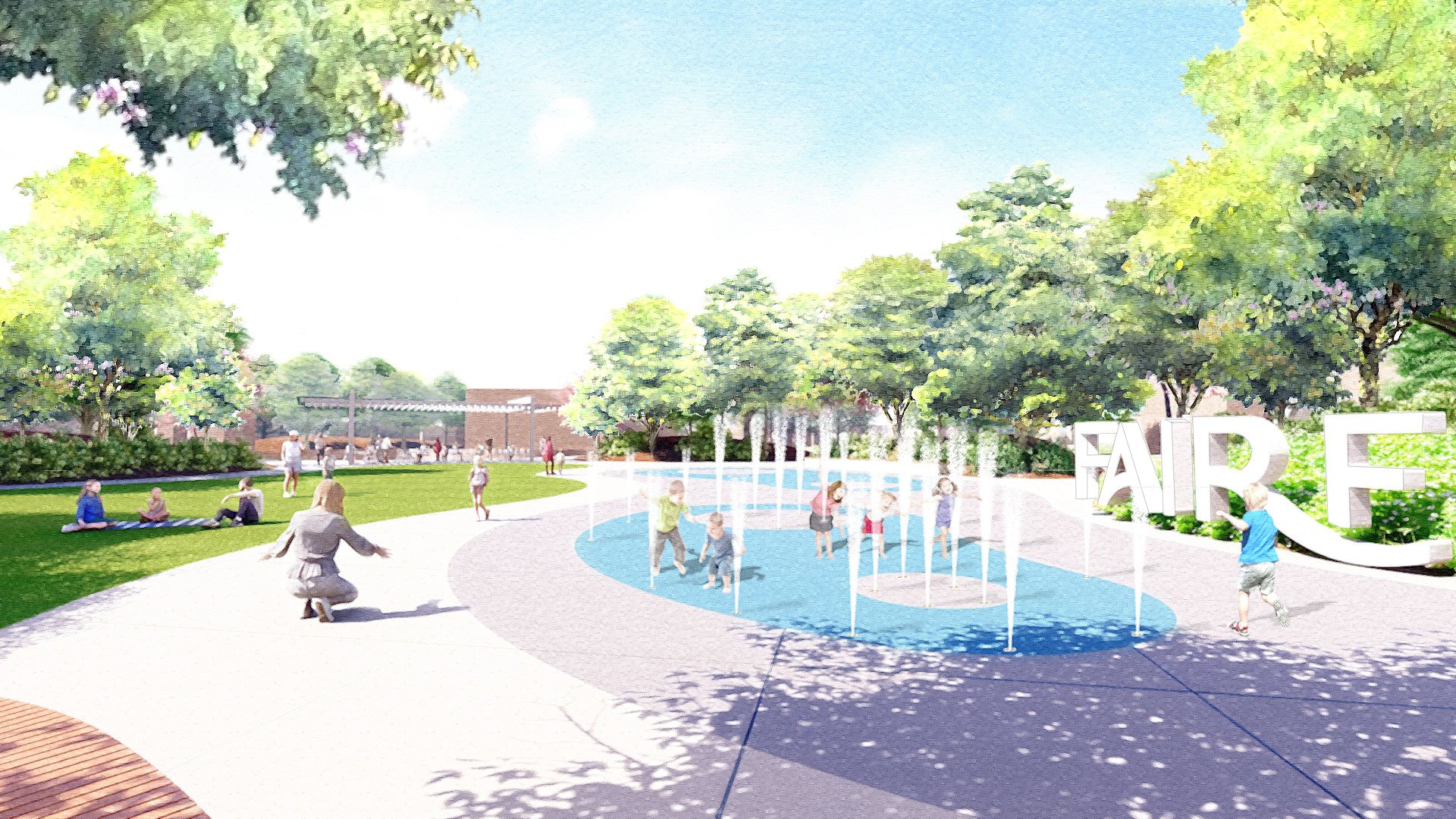
Urban Planning & Design Designing Local 9/23/24 Urban Planning & Design Designing Local 9/23/24 Fairfield Town Center Placemaking Strategy Read More
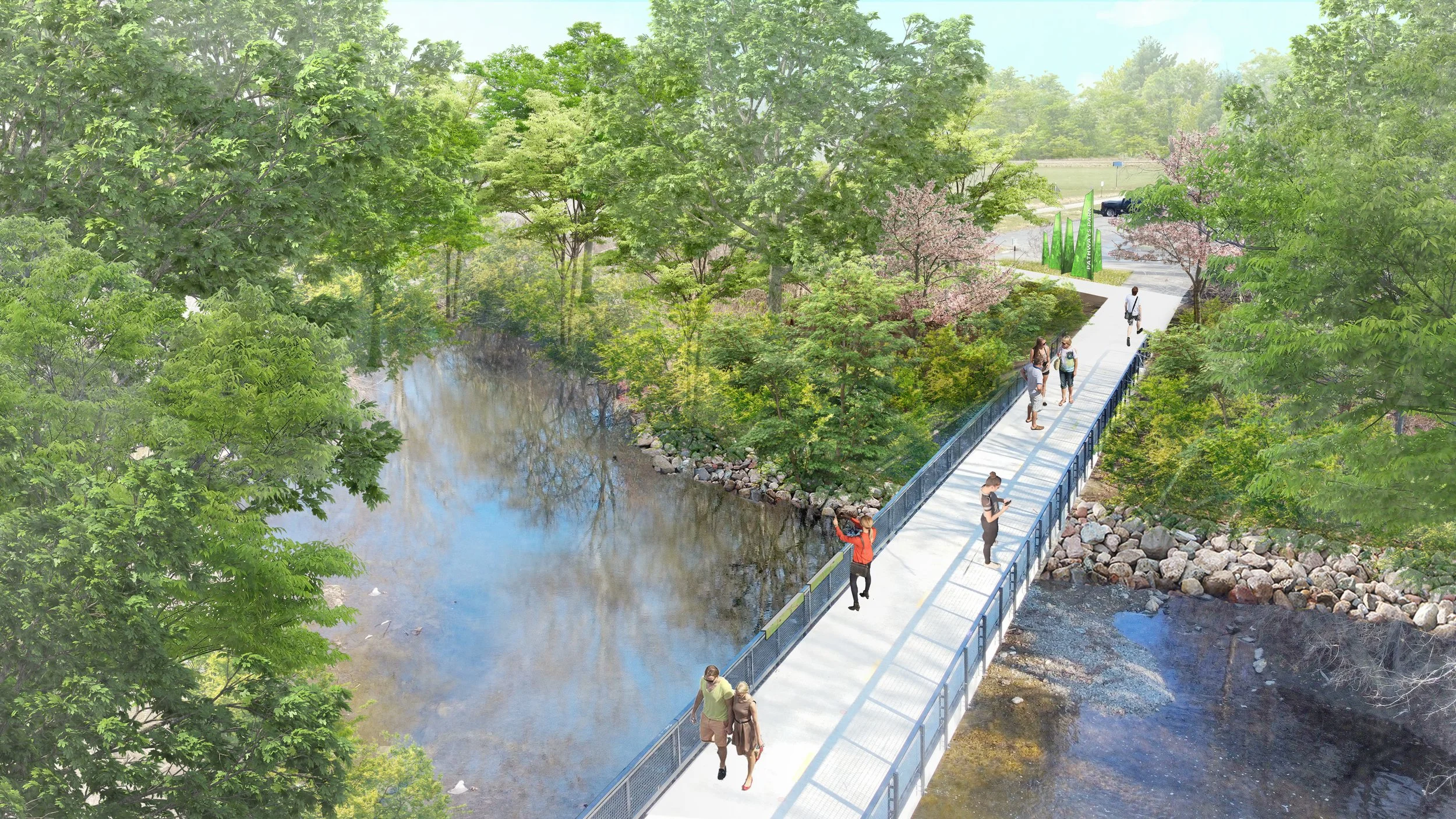
Landscape Architecture, Urban Planning & Design, Parks & Recreation Matt Leasure 8/16/24 Landscape Architecture, Urban Planning & Design, Parks & Recreation Matt Leasure 8/16/24 Rickenbacker Woods Park Read More
Urban Planning & Design, Parks & Recreation Designing Local 4/5/24 Urban Planning & Design, Parks & Recreation Designing Local 4/5/24 Central Ohio Greenways Wayfinding Strategy Guide Read More
Landscape Architecture, Urban Planning & Design, Community Engagement, Parks & Recreation Matt Leasure 10/17/23 Landscape Architecture, Urban Planning & Design, Community Engagement, Parks & Recreation Matt Leasure 10/17/23 Fort Wayne 5-Year Parks & Recreation Master Plan Read More
Landscape Architecture, Urban Planning & Design, Parks & Recreation Matt Leasure 10/17/23 Landscape Architecture, Urban Planning & Design, Parks & Recreation Matt Leasure 10/17/23 New Haven- Adams Township 2023-2027 Parks & Recreation Master Plan Read More
Urban Planning & Design, Landscape Architecture, Parks & Recreation Matt Leasure 10/17/23 Urban Planning & Design, Landscape Architecture, Parks & Recreation Matt Leasure 10/17/23 Allen County Parks 2023-2027 Parks & Recreation Master Plan Read More
Historic Preservation, Landscape Architecture, Urban Planning & Design Matt Leasure 6/15/22 Historic Preservation, Landscape Architecture, Urban Planning & Design Matt Leasure 6/15/22 Ohio & Erie Canal Southern Descent Heritage Trail Read More
Landscape Architecture, Urban Planning & Design, Parks & Recreation Matt Leasure 6/15/22 Landscape Architecture, Urban Planning & Design, Parks & Recreation Matt Leasure 6/15/22 Lockbourne Veterans Park Read More
Landscape Architecture, Urban Planning & Design Matt Leasure 6/15/22 Landscape Architecture, Urban Planning & Design Matt Leasure 6/15/22 Columbus Urban Forestry Master Plan Read More
Landscape Architecture, Parks & Recreation Matt Leasure 10/1/21 Landscape Architecture, Parks & Recreation Matt Leasure 10/1/21 Tuttle Park Lower Field Improvements Read More
Landscape Architecture, Urban Planning & Design, Parks & Recreation Designing Local 9/13/19 Landscape Architecture, Urban Planning & Design, Parks & Recreation Designing Local 9/13/19 Cape May County Creative Placemaking Plan Read More
Landscape Architecture Matt Leasure 5/28/19 Landscape Architecture Matt Leasure 5/28/19 Dublin Arts Center Event Terrace & Cabin Reconstruction Read More